
How SAR Drone and Direction Finder Systems Are Improving Modern Search Operations
by Jack Brown May 29, 2026
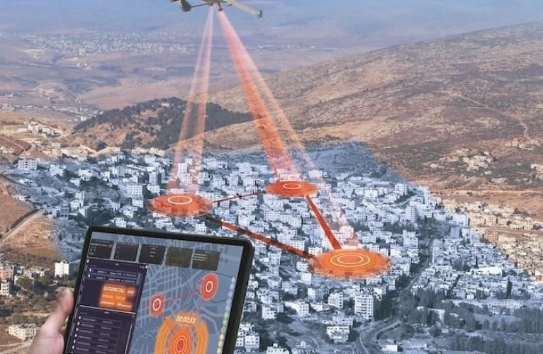
Modern search and rescue missions require fast action, accurate coordination, and reliable situational awareness. Emergency response teams often work in highly challenging environments where locating missing individuals quickly can make a critical difference. Forests, mountains, disaster zones, remote landscapes, and flood-affected regions can all create major obstacles during rescue operations.
As technology continues to evolve, rescue organizations are adopting smarter tools that improve operational efficiency and reduce search time. One of the most important advancements in recent years is the integration of SAR Drone platforms with advanced Direction Finder technology.
Traditional search methods can be slow and resource-intensive. Ground teams may need to cover large areas manually while dealing with difficult terrain and limited visibility. In emergency situations, delays can increase operational risks and reduce the chances of a successful rescue outcome.
A SAR Drone helps solve many of these challenges by providing rapid aerial coverage of large environments. Drones can quickly reach areas that may be difficult or dangerous for responders to access directly. They provide live aerial visibility that helps teams understand the operational environment in real time.
Modern rescue teams use SAR Drone systems to monitor remote areas, support disaster response missions, and improve overall search coordination. The ability to deploy aerial support within minutes allows emergency teams to gather critical information much faster than traditional ground-based methods alone.
While aerial visibility is highly valuable, many rescue situations also require signal detection capabilities. In some scenarios, missing individuals may carry communication devices, emergency transmitters, or radio equipment that can assist responders during the search process. Identifying the direction of these signals can significantly improve search accuracy.
This is where Direction Finder technology becomes essential.
A Direction Finder is designed to detect and track the direction of radio-based signals. When integrated with a SAR Drone, the system allows operators to combine aerial movement with real-time signal awareness. This creates a more advanced search capability that helps responders narrow down target locations faster.
Instead of searching large areas blindly, rescue teams can use signal direction data to focus on higher-priority zones. This improves operational efficiency and reduces the amount of time required to locate individuals during emergency situations.
The combination of SAR Drone systems and Direction Finder technology is especially useful in difficult search environments. Forested regions, mountainous terrain, and disaster-affected areas often limit visibility for ground teams. Aerial signal detection provides an additional layer of operational awareness that supports faster response strategies.
In wilderness rescue operations, for example, drones equipped with Direction Finder systems can scan wide search areas while monitoring for radio signals below. This capability helps emergency teams identify potential locations more quickly than manual searching alone.
One of the major benefits of using a SAR Drone during rescue operations is improved Safety for responders. Entering unstable or hazardous environments without situational awareness can place emergency personnel at risk. Drones allow operators to assess conditions remotely before deploying teams into dangerous areas.
Direction Finder technology further improves operational planning by helping responders understand where signals may be originating. This information allows rescue coordinators to allocate resources more effectively and prioritize specific search zones.
Real-time awareness has become a major priority for modern emergency response organizations. Rescue teams need technologies that help them gather information quickly and respond to changing conditions without delay. Combining aerial mobility with signal detection creates a more intelligent and efficient search process.
Artificial intelligence is also beginning to enhance drone-based rescue operations. Advanced systems can analyze environmental data, monitor movement patterns, and assist operators in identifying important operational information in real time. These technologies are expected to play a growing role in future rescue missions.
Public safety agencies and emergency organizations around the world are increasingly investing in advanced aerial technologies that improve coordination and operational awareness. SAR Drone systems equipped with Direction Finder capabilities are helping responders operate faster and more effectively during time-sensitive missions.
As search and rescue operations continue to evolve, integrated drone systems will likely become even more important in emergency response environments. The ability to combine aerial surveillance, signal tracking, and intelligent operational support into a single platform represents a major advancement in modern rescue technology.
In situations where every minute matters, access to real-time aerial intelligence can improve decision-making, reduce search times, and support more successful rescue outcomes for emergency response teams worldwide.
tags:

Safe driving is about more than simply knowing traffic laws. It requires awareness, patience, good...

Learning to drive is one of the most rewarding milestones in life. It offers independence,...

Choosing the right transportation service can make every journey more comfortable, convenient, and stress-free. Whether...